blue mountains, jamaica

It’s a weird place to be in when you choose to make yourself a sleep-deprived, stressed-out human being. I don't think I am alone in this; it's an easy spot to find yourself in.  You want to do all the things whether it's being successful at work, having the grandest adventures, or even just managing to keep the 4,938 parts of your life together.  The thing is it's not sustainable - or at least it is not for me.  

Throughout this past winter, I took my hibernation seriously and by the time spring arrived I was ready to bust out of survival mode.  My program offers a 6 week study abroad so my new year's goal became to have my life organized enough to take advantage of that opportunity.  Also, did I mention one of the options was to go to Jamaica?  Who doesn't want to spend spring soaking up the sun and enjoying all things island life?

image.jpg

I arrived in Jamaica with some big goals in mind, especially coming off the high of choosing to leave a job and move out of my apartment of almost 4 years.  Go big or go home? Much of the past 12 months has been spent constantly playing catch-up at work and/or school and to be honest I was wholeheartedly exhausted.  I wanted nothing more than to create some stability in my life, reorganize my priorities, and take some time to breathe.  

Perhaps then it is no surprise that upon arriving in Kingston, all I wanted was to escape my new urban environment, stretch my legs, and get some mountain air in my lungs. (Side note: you may have thought being that I was in the Caribbean my first order of business would be to get my bum to the beach, especially given my love of salt water.  I know.  I am just as surprised as you are. Judge away.)  Interesting life choices aside, my first weekend in Jamaica and I found myself packing my bag for a 24 hour getaway to the Blue Mountains.  Three hours of rain-filled, nausea inducing twisty roads later, including a very necessary pit stop to switch out a glorified hatchback for a Land Rover, I arrived at a guesthouse run by some Rastafarians. 

image.jpg
image.jpg

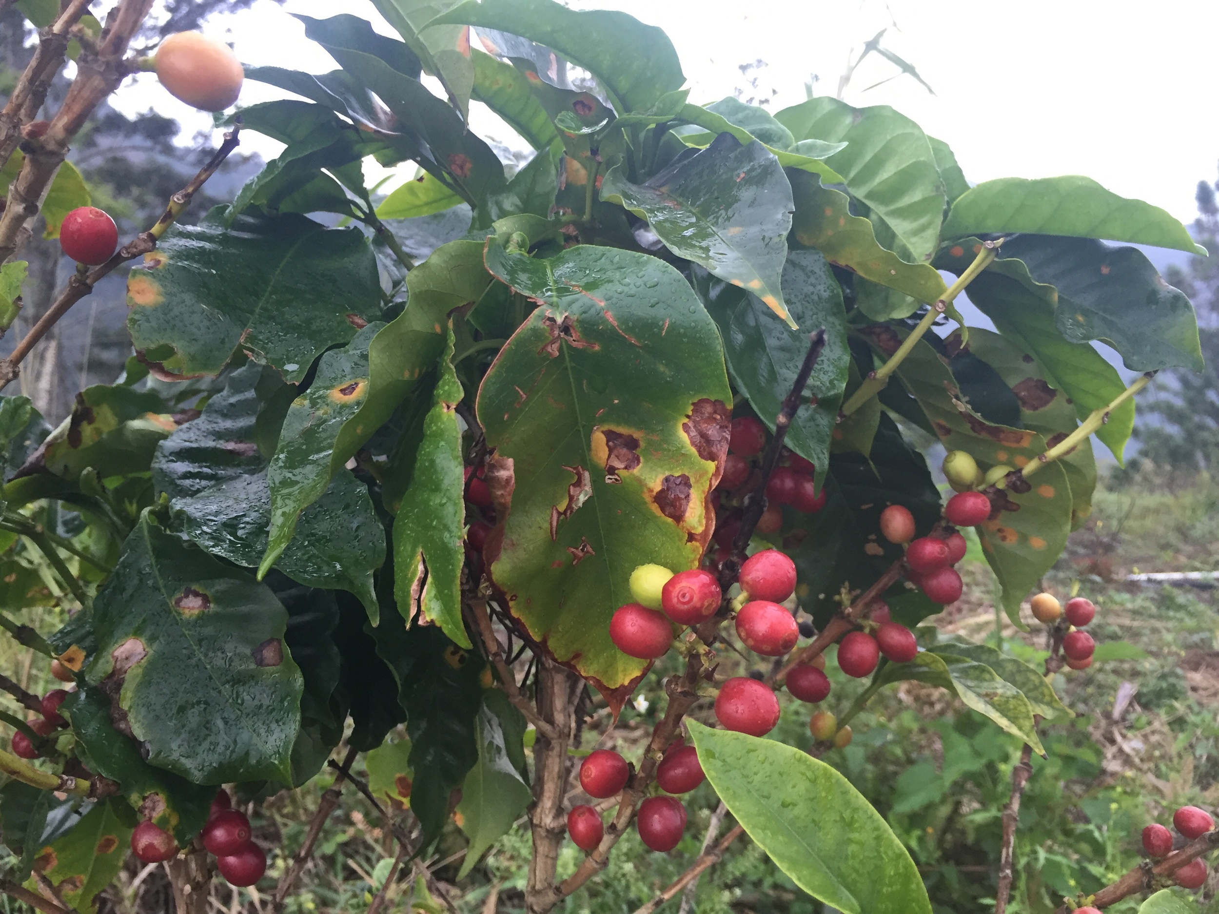
As the rains began to let up, the surrounding property glistened in the intermittent late afternoon sun.  Not to be all sappy (but to be sappy), it was magical.  I wandered about the property, investigating the various fruits and vegetables growing and stumbling into some hooved garden thieves.  The only sounds to be heard were the crunching of earth under my feet, the reawakening of evening birds and bugs, and an occasional goat bleating presumably in protest to being identified as an interloper.  As I stretched my legs out scampering up and over the garden’s sloped paths, I was tempted to just scurry up the trail to the peak.  I would have to wait though until the early morning hours of the following day.  Mostly because I was not traveling alone but also because everyone I had spoken to about the Blue Mountains either thought I was a ridiculous person for wanting to ascend them or insisted that I arrive at the peak for sunrise.  Watching the sunset over the range, I was able to catch a glimpse of the hillside down to the sea giving me hope for what the following day’s hike had to offer.

image.jpg
image.jpg
image.jpg
image.jpg

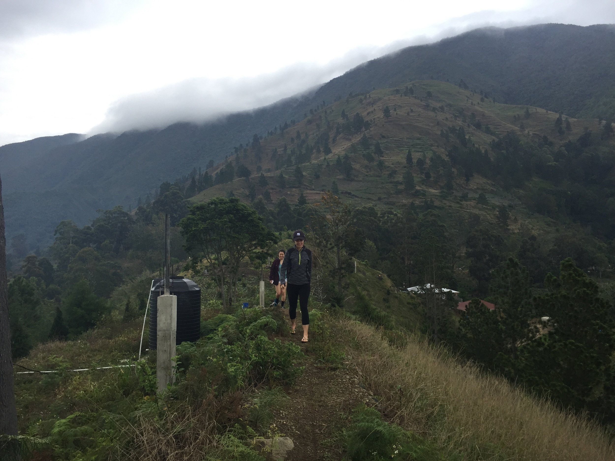
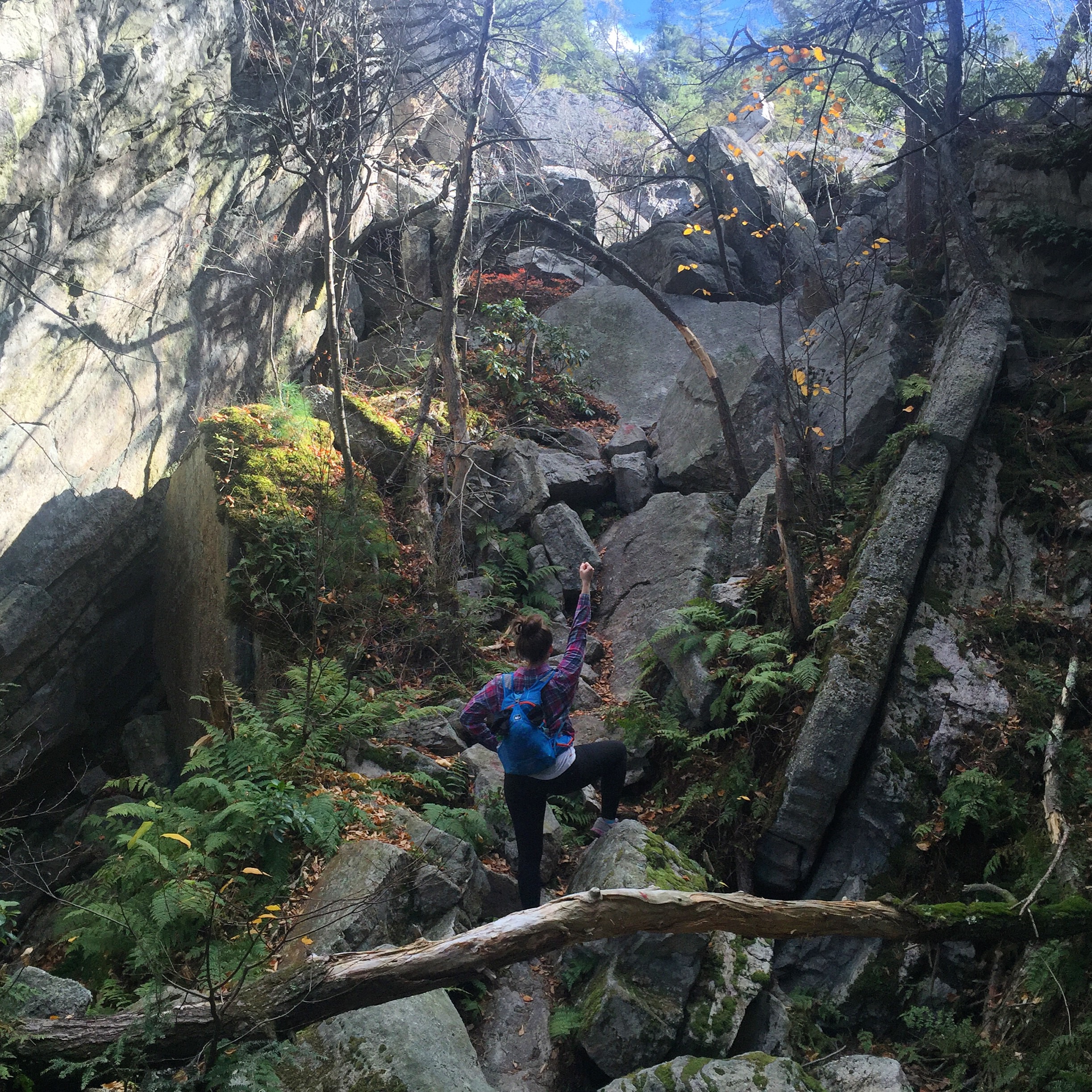
Because of our planned 2 am departure, we asked Everton, the guesthouse caretaker for the weekend, to lead the way.  After a quick cup of coffee, we were on our way into the dark and misty morning.  As we slowly began our climb, what had started as a mere misting turned to more of a drizzle.  To be honest, I welcomed the initial drops as even in the early hours of morning I was beginning to feel the heat.  Up and up my legs carried me and as the weather became more miserable and damp, my persistent attention on the seemingly large issues in my life faded out until all I could do was focus on the present.  We ascended as a group, ensuring that no man was left behind and creating a lighthearted atmosphere to counteract the nagging question of what in the world were we doing for hiking 16 miles in the cold, pouring rain. 

image.jpg

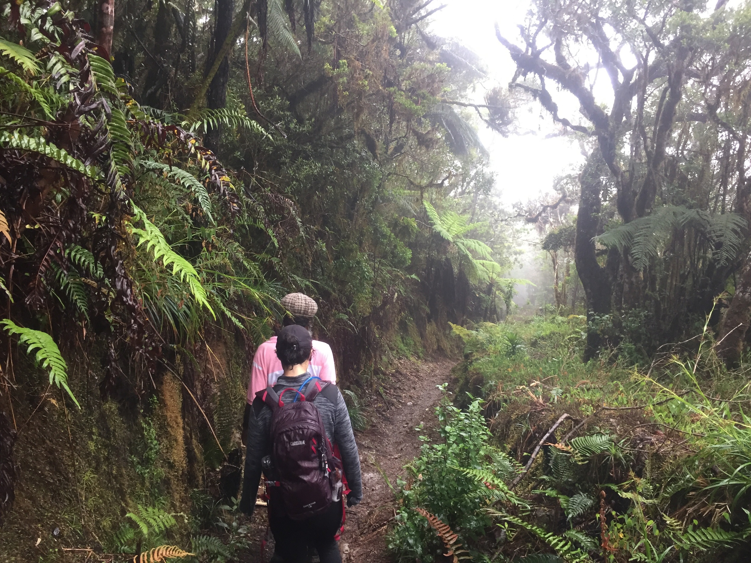
Eventually, we made it to the peak which was completely surrounded in fog.  I couldn't see more than 30 feet in front of me let alone Cuba.  After the obligatory peanut butter sandwich eating and documentation of making it to the top, we began our descent, retracing our steps.  It didn’t take long for most of our group to make a literal run for it while my friend and I moseyed along accompanied by Everton.  If it wasn’t for a friend with hesitancy towards slippery, downhill slopes, I probably would have been part of the speedier pack.  

image.jpg
image.jpg

I can have a tendency to rush through things.  Racing from one thing to the next, always scheming another adventure in my brain, at times to the detriment of the present.  Instead the way back down was filled with the sounds of rain hitting the forest canopy, a few birds braving the weather, and the intermittent songs and commentary from our mountain guide.  I have to admit I had begun to romanticize the Rastafarian life - I could live simply in the mountains, surviving off my vegan farm, trekking down to the sea for surf on the weekends.  But as Everton shared about his life, it became clear that his life was anything but simple.  Which yes, of course, because people are people and we all have these messy, sometimes beautiful, sometimes ugly, lives.  His family was scattered across the globe, the magical and organic farm I loved was under constant threat of being contaminated from the neighbor's pesticide use, and he too was wondering why he agreed to take us up the mountain this damp and drizzly Sunday. 

image.jpg
image.jpg

The funny and glaringly obvious life lesson here is that even if you can change your location oftentimes the situation remains the same.  Don’t get me wrong; Jamaica was/is absolutely amazing.  I loved my mountain retreat (despite the cold/rain/fog/clothing soaked through to my skin), however my work, school, life responsibilities didn’t suddenly disappear when I stepped off the plane.  As much as I wanted all the loose ends to be tied off and neat tick marks next to every item on my to do list, it just didn’t happen despite my best efforts.  I’m slowly learning that’s ok, emphasis on slowly.  In the meantime, I'll be here just daydreaming of my vegan farmer/surfer lady lifestyle.

image.jpg

notes:

if you’re down with [nice] hostel accomodations and cold showers, stay at Jah B’s Guesthouse. and please, buy the coffee.  it is delicious and far better than the more expensive varieties i was able to find in kingston. 

bring snacks with you, especially if you plan to hike before sunrise.  while coffee was provided, about thirty minutes into the hike you’ll be wishing you had some food in your belly.  if you are hiking with a guide, bring extra snacks to share - they will be much appreciated.

mohonk preserve, ny

We knew it was bound to happen when the plan was made or at least I knew it was bound to happen.   I have a tendency to come up with grand adventures but sometimes the certain logistical details get lost in the shuffle. In this case it was the timing of our arrival at Labryinth in Mohonk Preserve – it was noon on an unseasonably warm and beautiful fall weekend. 

image.jpg

Already Grace and I were stuck in a queue amongst strangers on the side of a cliff.  The murmurings behind us were mostly comprised of teenage daughter stating why her friends are ‘the worst’ and midlife crisis dad wanting to take any path but the one marked.  Oh and I should definitely not leave out the ceaseless whining from the entire family because another thing that’s ‘the worst’ is waiting. 

As we stood there attempting to ignore the background bickering, the sound of a young girl giving out a quick yelp rang out followed by tears.  I uncontrollably let out a small sigh.  This was the proverbial icing on the cake.  After a morning of scrambling over, under, and sometimes seemingly through rocks pretty much by ourselves, all I wanted to do was climb.  This new situation caught me a bit off guard and not necessarily in a positive way.  But before I could get too discouraged (read: grumpy), the little girl’s mother offered some encouraging words and with that she was off happily scampering up and over the path’s boulders as though the fall had never happened. 

image.jpg
image.jpg

There are moments in life when I really want to have a bad attitude and this was on of them but the group behind us just wouldn’t let me.  They were a sot of blessing in disguise because when you hear a constant stream of someone else’s grumblings it forces you to acknowledge how unattractive it is.  Being surrounded by other human beings all working toward the same goal was not a problem.  We were not racing to the top; we were there to enjoy some fresh mountain air and attempt to catch the changing leaves before winter sets in.  As for the temporarily upset young girl and her family in front of us, they ended up being this amazing group of four that just loved each other so much you couldn’t help but smile. Had I allowed myself to get wrapped up in my own little world, I never would have known the greatness in front of me. 

So get yourself outside this weekend.  Take the time to explore the Preserve and embrace the craziness that is a weekend fall day at Mohonk.  It’s worth it and you never know whom you’ll meet. 

image.jpg

If you want to avoid paying a whopping $26 per hiker and are up for a 9-10 mile trek, here’s how we made our way to Labyrinth and Lemon Squeeze:

-       Park at West Trapps Trailhead and pay the friendliest attendants $12 per hiker.

-       Follow the Undercliff Trail for about 2 miles until it feeds into Laurel Ledge Road.

-       After about a ½ mile, turn right on to the blue Giants Workshop Trail.  Climb up and over and through the various boulders.

-       When you reach a rock slab viewpoint, continue up and to the right on the red Humpty Dumpty Path.  It may be a bit difficult to see initially – trail blazes are affixed to trees and painted on rocks.

-       At the end of the scrambles, you’ll reach the Humpty Dumpty Road.  Turn right and stay on this path for about ¼ mile.  The trail branches into the Long and Short Woodland Drives.  Take the short one to the left unless you want too add some extra mileage to your legs.  On your left you will pass Lake Shore Path and Woodland Path.  Both of these will lead you to Lake Shore Road but you can also stay on Short Woodland Drive to get there. 

-       The entrance to the Labyrinth is off of Lake Shore Road near the Mountain House (you can’t miss it).  There are multiple access points but it is best to start at the very beginning just don’t be surprised should you see interlopers.

-       The path to Labyrinth and Lemon Squeeze is straightforward, especially compared to the scrambling at Giant’s Workshop.  Make sure to continue all the way up to the top of the tower – the view is worth it.

-       To get back to the West Trapps Trailhead, the quickest route back down is the Sky Top Path.  It’s a dirt trail off the main Sky Top Road to the north of the Tower (when you exit the Tower, it is on your right). 

-       The Sky Top Path leads back down to the Lake Shore Road.  The rest of the trails are old carriage roads: Lake Shore Road (turn right on to it) to Old Minnewaska Road (straight ahead) to Rhododendron Bridge (on the right) to Overcliff Road (straight ahead) to West Trapps Trailhead.

image.jpg

notes:

if you are afraid of heights and/or unsteady on your feet, stick to the trails and off of the scrambles, especially the non-labyrinth/lemon squeeze ones.  also avoid these trails in inclement weather because wet rock and giant gaping holes to plummet to one’s death just don’t get along. mohonk closes down sections of the preserve, including the scrambles, depending on the weather and season. call ahead to make sure they are still open for all of your adventuring plans (845 256 2197).

check out this dude’s blog for trail suggestions/descriptions at mohonk.  it even links to this handy map in case you’re the type to plan ahead as well as some post-hike grub suggestions. 

image.jpg

geocaching in the san jacinto mountains

I fell in love with geocaching over the summer during my family’s epic annual camping trip.  One cloudy morning up in the Adirondacks, my cousins and I loaded up the kayaks and canoes and made our way around the various lakes and islands in search of caches. 

image.jpg

In case you have never heard of geocaching before, it is basically a worldwide scavenger hunt.   There are millions of caches from in all different locations – airports, cities, woods, beach.  The easiest way to geocache is download the app.  (Yes, it costs some money and no, I have no stock or relatives or the like in the company.)  For each cache, the longitude and latitude pinned to its location.  Keep in mind that that there is a range of distances, usually within 10 feet, as the pin is only as good as your GPS.  Once you find the area, search all about for a little box or canister.  People are clever so the caches are not always easy to find.  Each typically contains little trinkets to be swapped and traded, i.e., don’t take something without leaving something, as well as a pad of paper to record your date, name, and sometimes a little message.

image.jpg

This past weekend, I headed up into the San Jacinto Mountains with some friends.  While we were hiking, I literally stumbled upon a cache.  It was right under my toe in the above picture (I also fully support nonsensical photo taking, obviously) and tripped me up a bit.  A wiggling of some wood jammed in the tree stump and lo and behold there was a box.  Remembering that I had downloaded the app this past summer, we continued on our way finding all sorts of treasures along the trail. 

image.jpg
image.jpg
image.jpg

I realize that some of you may roll your eyes at the idea of grown people running all over the trail trying to find teeny troves of treasure.  And maybe this isn’t for everyone but don’t knock it until you try it, okay?  There are many options for fellow scavenger hunters, especially along the trails in close proximity to Idyllwild.  We did a relatively easy 5 mile out-and-back along the Ernie Maxwell Scenic Trail.  Since we started on the earlier side, around 10 am, we only saw a few people on our way out.  However, by the time we were on our way back there were many people taking advantage of the cooler weather and cloudless sky. All in all a perfect little adventure for a day spent up in the San Jacinto Mountains.  

image.jpg

notes:

the ernie maxwell scenic trail has about 600 feet of elevation change.  if you would like to hike uphill on the way out and downhill on the way back, park on tahquitz view drive.  it’s a dirt road but i doubt any vehicle would have trouble with the terrain.  if you are having trouble figuring out how to get there or are interested in a ascending one the nearby peaks, stop by the idyllwild ranger station in town.  the lovely people there are always happy to help.

the weather in the san jacinto mountains can vary by 10s of degrees so be sure to pack layers (along with your other essentials).  it reached the high 70s while we were there but i’ve also been here around the same time of year an woken up to snow. 

wanderlust wednesday: car camping

Given the amount of attention backpacking gets in these here parts, one may be lead to believe that I favor backpacking to car camping.   That simply is not true. Ok, maybe it is a little bit true but when the air becomes crisp and I find myself craving for a home with a hearth, car camping is where it is at.  Let's be real folks, my dreams of an apartment with a fireplace, yard, and parking space are not going to be realized any time soon. 

image.jpg

The addition of a vehicle and a prescribed camping spot enables cold-blooded people like me to enjoy the great outdoors.  The other weekend I brought camping no fewer than 2 jackets, 2 sweatshirts, 1 long sleeved tee, 1 tank top, 2 pairs of pants, a couple pairs of socks, hat and gloves not to mention various sleeping bags/pads.  With the forecast predicting nightly temperatures in the 20s, I left nothing to chance. Being properly bundled meant I could actually enjoy the great outdoors and fully embrace the arrival of fall.  And to be a complete cheese ball, there’s something magical about the combination of autumn air, roasted marshmallows and bourbon-spiked cider around a campfire with friends.   For us New Yorkers, these next few weeks look ideal for those of you wanting to venture out on your own car camping adventure. If you're up for it, here's what I would recommend for the perfect fall getaway:

image.jpg

STAY

At the risk of sounding repetitive, Harriman/Bear Mountain State Parks are the perfect locale for a weekend camping trip.  They're only about an hour from the city and the parks are big enough to experience something new every time you visit.  Beaver Pond Campground is open through the end of October on a walk-in basis.  We had no trouble securing a spot last Saturday and there were plenty of places to park your tent without being on top of your neighbors.  If you're looking for something within the city limits, try Floyd Bennett Field in Brooklyn.  And for those of you sans gear and car, check out Malouf’s Mountain in Beacon. 

EAT

S'mores are a must in this environment and frankly it would be a sacrilege to go without.  I'm more of a deconstructionist (each element consumed separately, please) rather than a purist but some version of graham crackers + marshmallows + chocolate are an absolute necessity.  Also, we are all adults – get the good stuff.  With regard to meals, pick up some trail mix, jerky, and apples for an easy hiking lunch.  Cheesy sandwiches that can be wrapped in tin foil and thrown on the fire make for a delicious dinner. For breakfast, get yourself to a diner after breaking down camp and questioning your sanity.  Your hair will be matted across your forehead, your derriere will be lumpy from all the added layers, and you will have a particularly musty scent affixed to your clothing.  Fear not, the locals won’t notice you and the kind wait staff will happily serve you up the best hot coffee and fried eggs. 

SLEEP

The drop in temperature is no joke, especially for someone who spends most of the winter under an electric blanket. (Don’t knock it until you try it).  In addition to the standard tent (do not forget the fly) and sleeping bag, I highly recommend a sleeping pad.  It not only provides a nice cushion but also adds some insulation to help you stay toasty throughout the night.  Extra blankets and layers are also a good idea, especially since I find that a sleeping bag rated to 30 deg F means I can sleep comfortably in weather around 50 deg F.  Last but definitely not least, this is one of those moments when you want to sleep four people in a 4-person tent.  Body heat is an asset and now is the perfect time to get up close and personal with your friends.

Anyone else dreaming of a woodland weekend adventure? 

image.jpg

note:

most of these photos are from a hike to the old jackie jones fire tower (see below).  the views are epic (can you find the itty bitty nyc above?) but watch your step should you choose to climb it.  quite a few steps are missing and a number of boards are loose.  if you are staying at beaver pond, the park staff can help you with finding your way to the trail.  it's about 3 miles round trip if you go directly there and back.  

image.jpg

great falls park, va

I've given up on any attempt to quell my wanderlust.  I had all these concerns that I wouldn't be able to get out of town once I went back to school but it turns out I can still sort of swing it.  Emphasis on the sort of.  Essentially, my life consists of very little sleep during the week, a 24 hour sabbatical on the weekends, followed by an oh dear God why did I just do that to myself on Sunday night.  It’s a really healthy pattern of behavior (I kid, I kid). 

image.jpg

I guess the logical response to all of this would be to, you know, cut back a little.  Maybe I could spend every other weekend out of the five boroughs as opposed to my current pattern of every single one.  Or I could even just journey out a bit closer to home, say within a 50 mile radius or places easily accessed by public transportation.  But where would the fun be with those kinds of restrictions?  I already have two flights scheduled before the end of this semester and another one that I am trying to finagle so my current lifestyle won’t be changing any time soon.  Besides which, without these weekly escapades I never would have found out about this great (get it? I know, I am easily amused) little park just outside of DC.  

My recent discovery of Great Falls Park should not be all that surprising; I have never lived in DC nor do I possess an encyclopedic knowledge of the National Parks system.  Nevertheless, I considered it a great (never gets old…) find as it covers all of my current needs: people I love live near by (bonus points for happily joining/proposing shenanigans), giant slabs of rock to climb up/down/over, and trails that let you imagine you are alone in the woods every once in a while. 

image.jpg

As this particular adventure took place on a beautiful Saturday, it was pretty crowded by the visitor center but don’t let that discourage you.  Stop on by and say hello to the wonderful park rangers.  They will be more than happy to help you find the perfect paths to check out and they’ll even recommend ideal locales for post-hike libations.   The path along the Potomac River is fairly straightforward and the crowds thin out as you move farther away from the parking lot.  I wish that I had known that in addition to the views/nature/wildlife amenities, the park also boasts some great (I’m done – I promise) climbing spots.  All down the River Trail, people were setting up their harnesses and getting their ropes in order.  While I didn’t get to climb with all the bells and whistles, there were plenty of places to scramble and explore.  Since there are only 15 miles of trail, I recommend taking your time to mosey and explore the cliffs and crevices along the way.

The days were a bit longer and warmer when I was there but by now it should be prime  time for leaf viewing, scarf bundling, and post-hike hot toddy sipping.  All in all, a visit to Great Falls Park was the perfect way to spend an autumnal afternoon - go and see it for yourself!

image.jpg

notes:

i try to avoid backtracking on trails as much as possible.  in order to make the hike a loop, you’ll have to cut through the woods.  do not attempt this unless you have a strong sense of direction or are adept at using your phone’s gps.  for convenience, you can find a trail map here but still check in with the rangers.  they’re the best.

for some standard pub food and a selection of tasty beverages, check out the old brogue irish pub in great falls.  after filling up on one too many fried pickles, make your way to around the corner to great falls creamery.

there’s wildlife to be had in these parts of the woods including snakes.  i came inches away from crushing one with my foot.  we were equally traumatized by the experience.  watch your step – you have been warned.

trail guide: 24 hours in harriman state park

If you were in NYC this past weekend, or really anywhere on the Eastern seaboard, you may have spent considerable time cursing the dreary fall weather and wishing for summer’s sunny skies.  But Mother Nature is looking kindly upon us New Yorkers because these next few days and possibly (fingers crossed) the weekend as well are looking to be absolutely beautiful. 

image.jpg

As the days get shorter and the temperatures hint at dropping below the freezing point, I've been making a concerted effort to soak up every minute of sun I can get by hitting up the trails on some of the local mountains.  More often than not I find myself amongst the trees at Harriman/Bear Mountain State Park.

At just over an hour (sans traffic) by car and easily accessible via public transit, you really have no excuse to not go.  Also the trails are beautifully maintained by the New York – New Jersey Trail Conference, which means you won’t be haphazardly stumbling around 50,000+ acres.  That being said, there are seemingly endless possibilities of paths which can make choosing a few for a hike or attempting a backpacking trip quite the daunting task.  Since I was just there the other weekend, I thought I’d share where my friend and I went just in case you want to check it out yourself. Disclaimer: it's a detailed doozy - feel free to scroll on down a bit to the shortened version.

image.jpg

THE ROUTE

Park at Elk Pen which is off of Route 17 in Southfields, NY.

Make your way across the meadow to where there is a sign with many different destinations (pictured above). 

Follow the white-blazed Appalachian Trail off to the left.  It is a bit of up and downs for just shy of 2 miles until it reaches the Arden-Surebridge Trail (red blazes).

At this point, you could check out Lemon Squeezer but since we had our packs we continued on our way to the right along the Arden-Surebridge.  Make sure you choose the  correct direction.  When looking at the entrance to Lemon Squeezer, it is the first red-blazed trail on your right.

About a half-mile further, turn right on to Lichen Trail (L on white background).  Of all the trails our feet graced, this was one of my favorites.  We stopped here for dinner and watched the sun sneak behind the hills.  

After another half-mile, you will reach the end of Lichen, turn right on to the Ramapo-Dunderberg Trail (red blazes) and follow it for a half-mile to the shelter area.  Set-up camp or continue on your merry way if making this a day trip.

The Ramapo-Dunderberg continues for another  mile before reaching the turn off for the Nurian Trail (white blazes). We planned to take this route on our first pass but due to a missing blaze and yours truly with her head in the clouds, an extra mile and maybe 500 feet in elevation gain was added to our trip.  Don’t be like us (unless you love backtracking uphill) and make a right on top of the rocky peak.  If you start going steeply downhill for more than 100 feet, you have sadly missed the turn. 

After successfully making it on Nurian, the trail  meets up with White Bar Trail for a bit and at that point it is marked as a black N with a while background since the White Bar also uses white blazes.  It also kisses the yellow-blazed Dunning Trail.  Ignore these two trails and stay on Nurian through the Valley of Boulders until it reaches Stahahe Brook (red horizontal strip with a white background) on your right. 

For the rest of the hike, the trail is pretty flat and it pretty quickly feeds into the Arden-Surebridge Trail (red blazes) which lead back to Elk Pen.  This backpacking trip was short and sweet but not too shabby for having less than 24 hours to spend gallivanting outdoors.  And yes, we stayed out for the night but this could easily be hiked (or run – the footing was pretty solid) in one day.

image.jpg

THE SKINNY

Elk Pen >> Appalachian Trail >> Arden-Surebridge >> Lichen Trail >> Ramapo-Dunderberg >> Nurian >> Stahahe Brook >> Arden-Surebridge >> Elk Pen

THE STATS

Mileage = 8.75 miles
Best Elevation Estimate Using an App on my Phone = 1792 feet
Times I Was Temporarily Lost But It So Does Not Count = 1
Total Time Hiking+Eating+Sleeping = 20.5 hours

image.jpg

notes:

lichen and ramapo-dundergberg involved hiking on semi-smooth rock.  if it has been raining or is going to rain, these would probably not be my first choice.  also remember to look for cairns as well as blazes on these trails as the trail markings aren’t always that easy to see.  to avoid getting lost, i highly recommend downloading the aveza pdf maps app and then purchasing ny-nj trail conference maps for harriman.  you can then pinpoint your location to the trail map should you find yourself in a pickle.

harriman state park has a number of lean-tos that you are required to sleep in or near if you stay the night.  you will see many people not sleeping in the designated areas.  don’t be like those people.  the rules are in place to protect the park and come on now, if you are backpacking an hour from nyc chances are you are never going to be completely alone.  perhaps sad but true.

for more photographic evidence of what you would be getting yourself in to if you decided to follow our footsteps, check out this post